Fourth Edition Map of Rokugan
There is an excellent 4th Edition Map for Legend of the Five Rings at http://talesofrokugan.com/map/.
A slightly smaller one, made by Ed Rollins, can be found at this link: HERE
A slightly smaller one, made by Ed Rollins, can be found at this link: HERE
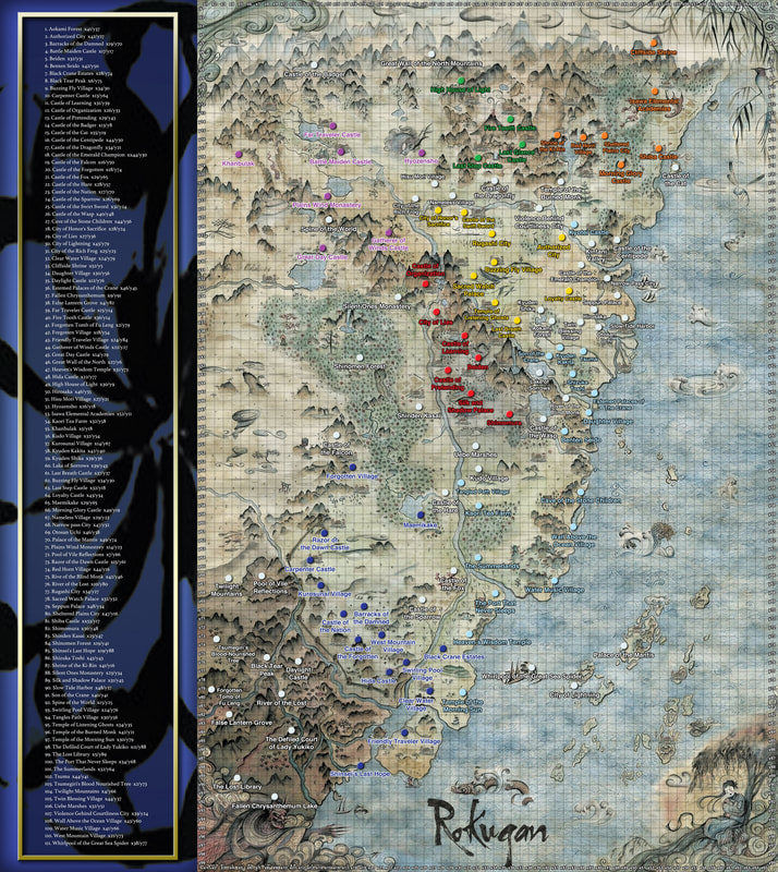
Fifth Edition Map of Rokugan with Scale
This 5th Edition map was constructed by Trevor Cuba (Kakita Onimaru) and contains all the locations from the Core Rule Book, Emerald Empire, Shadowlands, Courts of Stone, and Path of Waves.
The 5th Edition Core Rulebook reads: "The Emerald Lands, or “Rokugan” in the tongue of its people, comprise a vast, majestic countryside that stretches nine hundred miles from the pine valleys and snow-capped peaks of the Great Wall of the North mountains at one end, to the austere Carpenter Wall standing vigil along the country’s desolate southern border. Beyond the Wall lies the Shadowlands, a blighted land tainted by the influence of Hell itself, and dangerous for even the most legendary heroes to step foot within. At its widest point, Rokugan measures six hundred miles, from the Sea of the Sun Goddess in the east to the Burning Sands in the west."
Using these measurements, this map was configured for a 1000 miles length and 700 mile width (to account for water and non-Rokugan/Shadowlands terrain). Each square on the map, therefore, is 10 X 10 miles.
Notes:
I have gone through and counted the number of actual square miles covered by inhabited Rokugan, removing the Shadowlands area, the Plains above Evil, and the heart of the Shinomen Forest. It comes out to be 2609 squares on this map, or 260,900 Square Miles.
Full Hi-Res Map of Rokugan
The 5th Edition Core Rulebook reads: "The Emerald Lands, or “Rokugan” in the tongue of its people, comprise a vast, majestic countryside that stretches nine hundred miles from the pine valleys and snow-capped peaks of the Great Wall of the North mountains at one end, to the austere Carpenter Wall standing vigil along the country’s desolate southern border. Beyond the Wall lies the Shadowlands, a blighted land tainted by the influence of Hell itself, and dangerous for even the most legendary heroes to step foot within. At its widest point, Rokugan measures six hundred miles, from the Sea of the Sun Goddess in the east to the Burning Sands in the west."
Using these measurements, this map was configured for a 1000 miles length and 700 mile width (to account for water and non-Rokugan/Shadowlands terrain). Each square on the map, therefore, is 10 X 10 miles.
Notes:
- The location of Hirosaka and Twin Blessings Village differs from Path of Waves per the request of the author for the section, D.G. Laderoute.
- Violence Behind Courtliness City is listed as Imperial/Minor Clans/Neutral
- Validated by PDF for Core Rule Book, Emerald Empire, Shadowlands, and Courts of Stone, and by book for Path of Waves.
- The location of Kyotei Castle and Kintani valley is from Atlas of Rokugan, since there is no map in 5th Edition for this location.
I have gone through and counted the number of actual square miles covered by inhabited Rokugan, removing the Shadowlands area, the Plains above Evil, and the heart of the Shinomen Forest. It comes out to be 2609 squares on this map, or 260,900 Square Miles.
Full Hi-Res Map of Rokugan
Low Res Version